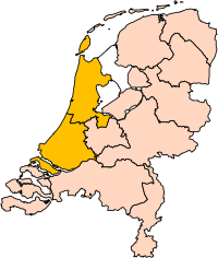
Tập tin:Holland position.svg

Kích thước bản xem trước PNG này của tập tin SVG: 200×236 điểm ảnh. Độ phân giải khác: 203×240 điểm ảnh | 407×480 điểm ảnh | 651×768 điểm ảnh | 868×1.024 điểm ảnh | 1.736×2.048 điểm ảnh.
Tập tin gốc (tập tin SVG, 200×236 điểm ảnh trên danh nghĩa, kích thước: 157 kB)
Lịch sử tập tin
Nhấn vào ngày/giờ để xem nội dung tập tin tại thời điểm đó.
| Ngày/giờ | Hình xem trước | Kích cỡ | Thành viên | Miêu tả | |
|---|---|---|---|---|---|
| hiện tại | 17:21, ngày 2 tháng 3 năm 2019 |  | 200×236 (157 kB) | Thayts | update |
| 15:34, ngày 14 tháng 1 năm 2007 |  | 200×236 (158 kB) | Roke~commonswiki | missed island | |
| 15:31, ngày 14 tháng 1 năm 2007 |  | 200×236 (158 kB) | Roke~commonswiki | edit to User:Mtcv's Image:Noord-Holland position.svg to show North and South Holland together. {{Statistics Netherlands map municipalities}} Category:Maps of the Netherlands |
Trang sử dụng tập tin
Có 1 trang tại Wikipedia tiếng Việt có liên kết đến tập tin (không hiển thị trang ở các dự án khác):
Sử dụng tập tin toàn cục
Những wiki sau đang sử dụng tập tin này:
- Trang sử dụng tại als.wiki.x.io
- Trang sử dụng tại ar.wiki.x.io
- Trang sử dụng tại arz.wiki.x.io
- Trang sử dụng tại ast.wiki.x.io
- Trang sử dụng tại ast.wiktionary.org
- Trang sử dụng tại az.wiki.x.io
- Trang sử dụng tại be-tarask.wiki.x.io
- Trang sử dụng tại be.wiki.x.io
- Trang sử dụng tại bg.wiki.x.io
- Trang sử dụng tại br.wiki.x.io
- Trang sử dụng tại ca.wiki.x.io
- Trang sử dụng tại cs.wiki.x.io
- Trang sử dụng tại cy.wiki.x.io
- Trang sử dụng tại da.wiki.x.io
- Trang sử dụng tại de.wiki.x.io
- Trang sử dụng tại de.wiktionary.org
- Trang sử dụng tại dtp.wiki.x.io
- Trang sử dụng tại el.wiki.x.io
- Trang sử dụng tại en.wiki.x.io
- Trang sử dụng tại en.wiktionary.org
- Trang sử dụng tại eo.wiki.x.io
- Trang sử dụng tại es.wikiquote.org
- Trang sử dụng tại et.wiki.x.io
- Trang sử dụng tại eu.wiki.x.io
- Trang sử dụng tại eu.wiktionary.org
- Trang sử dụng tại fa.wiki.x.io
- Trang sử dụng tại fr.wiki.x.io
- Trang sử dụng tại fur.wiki.x.io
- Trang sử dụng tại gd.wiki.x.io
- Trang sử dụng tại gl.wiki.x.io
- Trang sử dụng tại gn.wiki.x.io
- Trang sử dụng tại gv.wiki.x.io
- Trang sử dụng tại he.wiki.x.io
- Trang sử dụng tại hy.wiki.x.io
- Trang sử dụng tại ia.wiki.x.io
- Trang sử dụng tại io.wiki.x.io
- Trang sử dụng tại it.wiki.x.io
- Trang sử dụng tại it.wiktionary.org
- Trang sử dụng tại ja.wiki.x.io
- Trang sử dụng tại ka.wiki.x.io
- Trang sử dụng tại kcg.wiktionary.org
- Trang sử dụng tại kn.wiki.x.io
- Trang sử dụng tại ko.wiki.x.io
Xem thêm các trang toàn cục sử dụng tập tin này.

